How is it that estimated 14,000+ acres and more than 1100 patented mine claims are not shown on local maps in Salt Lake and Utah Counties? Read below for explanation.
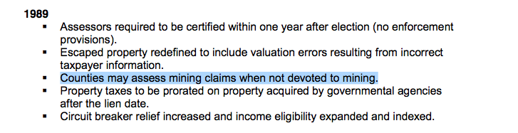
In 1989, the first year Gary Herbert was a Utah County Commissioner, the State Tax Commission noted counties to assess land that is not now mined.
What is the private / public land ownership in AF Canyon look like?
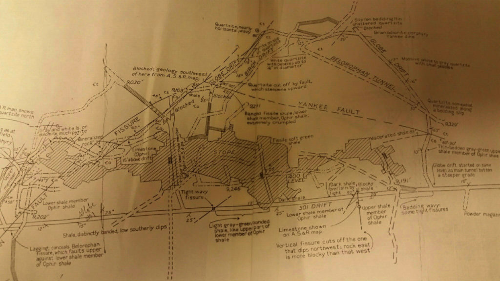
Map of Miller Hill, Mineral Basin and Mary Ellen Gulch.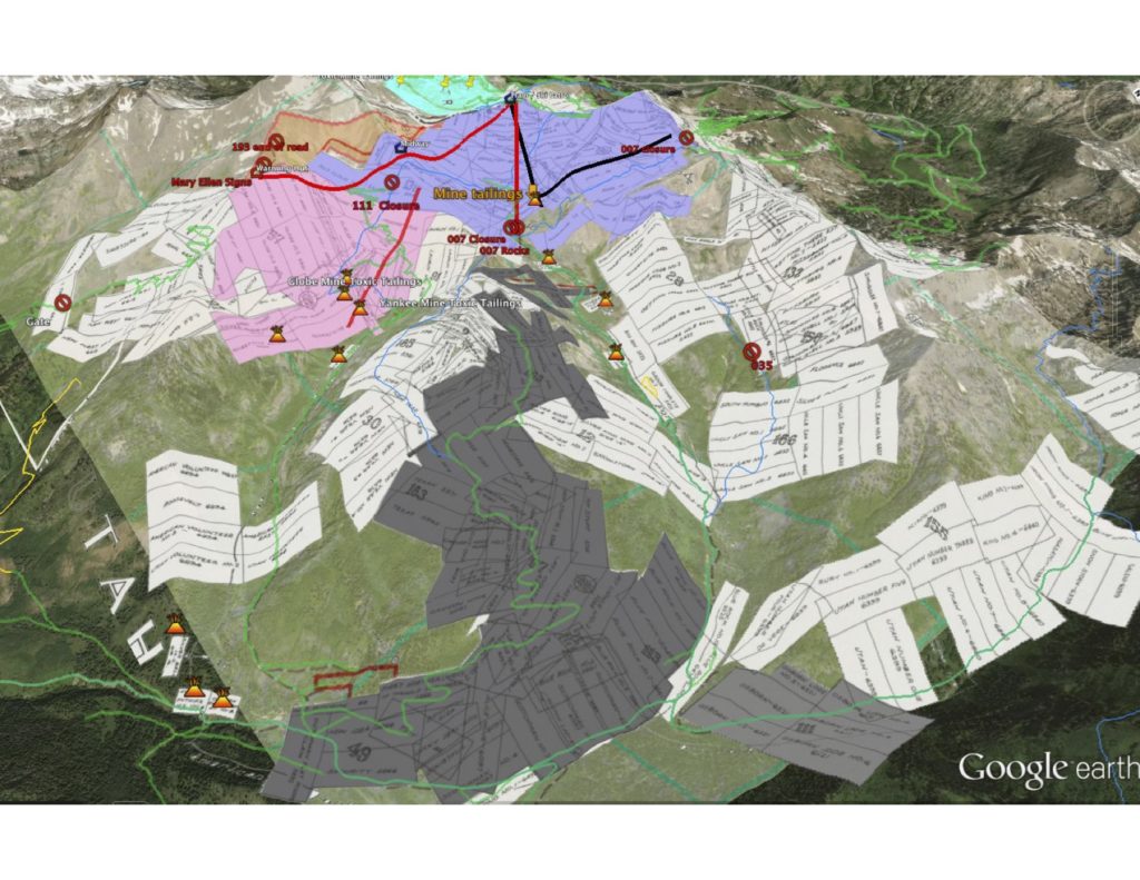 What does a mine look like? Below is a cross section of the Yankee Mine. A complex array of tunnels underground and just about as complex above ground to understand ownership, mine boundary overlaps etc. The reason why Central Assessing was involved in active mines.
This is a view of retired mines since 1977 (red) and (green) would show active mines that would qualify for Central Assessing in Little Cottonwood, Big Cottonwood or American Fork Canyon – however there are no qualifying mines, therefore all patented mine claims should be locally assessed, and maps made accurate.
It’s apparent that the ski resorts are in the recreational business not mining.
Utah State Tax Commission should conduct an audit and offload their central assessing tasks to the respective counties, ie Salt Lake and Utah County. That audit would be simple. All patented mine claims should be assessed locally. No active mines exist in these canyons. Central Assessing has been doing the work of local counties and the reason the maps are so inaccurate in American Fork, and also LCC and BCC.
Mines listed below that do not qualify for Central Assessing Valuation at the bottom of this page.
—-
While trying to figure out how to pay taxes on our small parcel of land in Upper AF Canyon- to protect public access to historically used lands for recreation. We reached out to Senator Valentine to ask why Central Assessing is doing the assessment work when these lands are not being mined and the use has shifted to that of recreational, namely skiing. His reply below.
“You asked the following question of the Utah State Tax Commission that came to me for agency response:
“Why does Utah State Tax Commission still do mine valuations for mines whose purpose is no longer mining? Utah County and SL County should do the tax assessment, and resulting mapping or land that is not longer actively mined. In 1989 the Central Assessing asked Counties to do this, why does the ill practice of Central Assessing persist? With Central Assessing doing land tax valuation, the patented mine claims never get added to county maps, not state maps- leading public to believe its all public lands. In turn this makes it problematic to determine the ownership of mines which pollute public lands. The BLM is working this year with Utah County Surveyor to start with mapping in AF Canyon, but LCC and BCC also need to be mapped.”
Tax Commission Answer: Utah Code Ann. Section 59-2-201(1)(a)(v) requires the State Tax Commission to assess “mines and mining claims except in cases, as determined by the commission, where the mining claims are used for other than mining purposes, in which case the value of mining claims used for other than mining purposes shall be assessed by the assessor of the county in which the mining claims are located…”
The State Tax Commission values all active mining claims and inactive mining claims where there is no active alternative use. If a mining claim’s active use has changed to something other than mining, the land is valued and assessed by the county in which it is located. If the active use of land being assessed by the State Tax Commission has changed to something other than mining, a land owner is required to present evidence of the change to the State Tax Commission.
The required evidence of the change is dependent on the specific facts and circumstances of each case but generally must demonstrate more than a mere temporary shift to a non-mining use.
Examples of acceptable evidence include, but are not limited to, the following:
*mine reclamation and return of the mine reclamation bond to the owner by the Division of Oil, Gas, and Mining;
*a recorded restrictive covenant or conservation easement running with the land which prohibits mining activities;
*local zoning which prohibits mining activities on the land; or
*evidence of conditions on the land that would render future mining activities impractical without great effort.
In all cases, however, it is incumbent on the property owner to request the change from Central Assessment to Local Assessment and provide the evidence of the changed use.
John L. Valentine
——–
Author comment
The loophole noted above in red. Legislatively we need to get an audit done of lands that are not mined and the responsibility should be to the county to do local assessment and to make maps accurate.
—-
So the response to Senator Valentine
“Senator Valentine,
Thank you for the information above. It’s pretty much how I have understood how things are supposed to be, yet are not. Both SL and Utah county have failed to apply these process changes noted nearly 30 years ago. This failure of local tax assessing and subsequent failure to map these lands as privately owned- created a perfect storm for ski resorts to purchase thousands and thousands of acres, and keep it off the radar of the public.
Perhaps 2018 will be a year of process change/compliance in all three major canyons (LCC, BCC, AF) which were once historically mined, to local assessment. To my knowledge and research, no active mining takes place currently in these canyons, nor has it for decades (LCC, BCC or AF Canyon). Do the resorts have to reach out for the change? It seems evident that the uses have changed to recreational and that Central Assessing should audit the mines / cross referencing with Division of Mining and make the appropriate change at the State Level, then push the assessments to local level. The onus should lay on the counties and states to determine such. Permits for mining can be readily cross referenced with the Division of Mining.
As Executive Director of American Fork Canyon Alliance, I would therefore request that our AFAC 501c(3) land purchased in AF Canyon be given a local assessment. We own a portion of the BoRussia claim. (See attached pdf). We have recorded the Warranty Deed, have filed a land survey with Utah County and have not been assessed taxes yet. The prior owner has likely been being over assessed and our portion not broken out since Central Assessing and Utah County Recorders offices do not cross share data sets. Local assessment pushes to the state data sets, these data sets are then used to make accurate maps. In order to get maps accurate in Little Cottonwood, Big Cottonwood and American Fork Canyon, it seems imperative that Central Assessing require the counties to do local assessment, this will result in county maps being made accurate, that data being uploaded to the state etc.
Thank you for the response and I look forward to having our parcel locally assessed. I do think that Snowbird and the Kimball properties in AF Canyon deserve the same process, which then will result in local maps being made accurate.
Mark Allen
Executive Director American Fork Canyon Alliance
Founding Member Protect and Preserve American Fork Canyon
Senator Valentines Reply.
Commissioner Valentine
—-
Now waiting on this to transpire. Once this is done, our AFCA property taxes should be assessed by Utah County. Our land survey should be put on county plat maps. That data will be uploaded to State databases and our land placed on all local and state maps. The resorts should be required to do likewise. The resorts had a perfect storm for buying land under the noses of the public. Some of these lands contain hazardous metals and accurate maps will help the EPA and local jurisdictions determine clean up responsibilities as well as provide the Forest Service maps so that they can determine what lands they actually manage in these canyons. As it is, the rangers can’t show the public what lands are public, what are private. 2018 should be the year to get this figured out.
—
The BLM is willing to help with mapping in AF Canyon. Utah County just needs to adopt these records until over the span of time, other surveys are added and things are gradually made as accurate as possible.
—–
https://gis.utah.gov/data/
Daniel W. Webb
BLM, Utah State Office (UT925)
Chief, Branch of Geographic Sciences
Chief Cadastral Surveyor, Utah
801-539-4135
dwebb@blm.gov
Senator Valentine.
I’ve not yet heard back about how to pay taxes on our American Fork Canyon Alliance property. After your last response to me, I started to look at how many other properties might be caught up in these wrong processes. Below is what I learned. This should be addressed on a state wide basis, otherwise maps will never be correct and conflict of private landownership will likely ensue.
I contacted Division of Mining to ascertain how many acres of land appear to be privately owned, and how many acres of land are Centrally Assessed- resulting in maps in our state being inaccurate. It appears from the data received, that more than 14,000 acres- spanning 1182 patented mine claims are Centrally Assessed- as a result, these lands are not depicted on maps.
This link ( http://
As part of my research I also contacted Division of Mining and was guided to an interactive map that shows “Active Mines”. That link is also found here. http://
It would be appreciated if proactively the State would require the counties to do this work, so that energies can be spent in correcting this loophole. Our group has been working with the former Surveyor General of the U.S., and a local surveyor to make our ownership accurate and represented on county maps. That same process of surveying land, recording the deeds at the local level is the proper process for all other land ownership issues. This loophole needs to be fixed. I welcome your response to this rather big issue.
Once maps are made accurate heavy metal ownership in the canyon can be ascertained. Even the EPA in their efforts in American Fork Canyon have not been able to identify accurate land ownership. https://www.sltrib.
With the proposed land swaps of the Mountain Accord, this too is problematic if land liabilities are not known before land it traded and the public inherits problematic mine tailings, millsites etc. laden with heavy metals or hazardous waste.
I welcome your response.
Respectfully
——
—–
How many parcels of land have not been locally assessed? 1180+ parcels and est. 14,153 acres of land.
____
To see detail on ownership Big Cottonwood Canyon mine ownership here.
https://docs.google.com/spreadsheets/d/1z0mr8zwKQArHBDkBTfpUkKL1gId467eX-_Fy-TtxoQ4/edit?usp=sharing
To see detail on ownership Little Cottonwood Canyon mine ownership here.
https://docs.google.com/spreadsheets/d/1B4Xy86jlwJgpD3BGyGl7Nue3fIMeJ8IrCLCYj4zhhBA/edit?usp=sharing
To see detail on ownership American Fork Canyon mine ownership here.
https://docs.google.com/spreadsheets/d/1wqzynPernBfTs1M6mD35CvW3PJElthJIIvePNBomWfc/edit?usp=sharing
| Big Cottonwood Claim Name | Little Cottonwood Claim Name | American Fork Canyon Claim Name |
| “99” | 1ST E EXT OF THE FREE COINAGE | 1ST WESTERLY EXTENSION OF THE MILLER |
| ABBEY | 1ST W EXT OF THE FREE COINAGE | ALASKA |
| ACUSHNETT | AETNA | ALDEBARAN |
| ADVANCE | ALASKA | ALICE MINE |
| AFTEN | ALASKA EXTENSION | ALPINE |
| AFTEN NO. 1 | ALBION | AMARYLLIS |
| AFTEN NO. 4 | ALBION NO. 1 | AMERICAN NO. 1 |
| ALCESTA | ALBION NO. 3 | AMERICAN NO. 2 |
| ALEX | ALBION NO. 4 | AMERICAN VOLUNTEER EAST |
| ALEXANDRIA NO. 1 | ALBION NO. 5 | AMERICAN VOLUNTEER NO. 5 |
| ALLEN | ALBION NO. 6 | AMERICAN VOLUNTEER WEST |
| ALPINE | ALBION NO. 8 | ANNA |
| ALPINE | ALFRED | ANNA |
| ALTA | ALICE | ASPEN |
| ALTON | ALICE NO. 1 | AUSTIN |
| AMANDA | ALLEGAN | BAY STATE MINE |
| ANTELOPE | ALLEGAN | BAY STATE NO. 1 |
| APEX NO. 1 | ALPHA | BAY STATE NO. 2 |
| APEX NO. 13 | ALTA | BELOROPHAN |
| APEX NO. 14 | ALTA FAY | BERNALD |
| APEX NO. 15 | ALWILDA | BERRY |
| APEX NO. 2 | ANGLER | BIG C |
| APEX NO. 25 | ANNA | BIG DAN |
| APEX NO. 26 | APEX | BIG EMMA |
| APEX NO. 3 | ARCO | BIG EMMA FRACTION |
| APEX NO. 4 | ARCO | BLUE BIRD |
| APEX NO. 5 | ARMSTRONG | BLUE JAY |
| APEX NO. 6 | BABBIE | BLUE ROCK AMENDED |
| ARGENTA | BALANCE TUNNEL | BLUE ROCK NO. 1 |
| ARGENTA NO. 1 | BANTAM | BLUE ROCK NO. 2 |
| ARGENTA NO. 10 | BELFOOT | BLUE ROCK NO. 3 |
| ARGENTA NO. 11 | BEN HARRISON | BLUE ROCK NO. 4 |
| ARGENTA NO. 12 | BERNALD | BLUE ROCK NO. 5 |
| ARGENTA NO. 13 | BLACK BEAR | BLUE ROCK NO. 6 |
| ARGENTA NO. 14 | BLACK JACK | BLUE ROCK NO. 9 FRACTION |
| ARGENTA NO. 15 | BLACK JACKY | BOG IRON |
| ARGENTA NO. 16 | BLUE BELL | BORUSSIA |
| ARGENTA NO. 2 | BLUE BELL NO. 2 | BORUSSIA MILL SITE |
| ARGENTA NO. 3 | BLUE BIRD | BOYD PARK |
| ARGENTA NO. 4 | BLUE BIRD EXTENSION | BREDEMEYER NO. 2 |
| ARGENTA NO. 8 | BOLIVER | BRIGHTON |
| ARGENTA NO. 9 | BOLIVER NO. 2 & FRACTION | C.D.H. |
| ARGENTINE | BONANZA NO. 10 | CANYON MINE |
| ARKANSAS TRAVELER | BOSTON | CANYON MINE NO. 2 |
| ASPOOS | BRADLEY | CANYON MINE NO. 3 |
| ASPOSS EXTENSION | BRAINE | CANYON MINE NO. 4 |
| AUGUST FLOWER | BROOKLYN | COPPER KING |
| AUGUSTA | BURNSWOOD | CUT OFF |
| AUGUSTA | C.K. | DEVERE |
| AZURE QUEEN | C.K. NO. 2 | DIEHL |
| BABY MCKEE | CABIN | DOLPHIN |
| BACHELOR MINE | CALCUTTA | DOUBTFUL |
| BACHELOR NO. 4 | CALEDONIA | DRYBURG |
| BAKER | CECRET NO. 1 | DRYBURGH FRACTION |
| BARNARD | CECRET NO. 2 | DRYBURGH NO. 1 |
| BARNEGAT NO. 1 | CECRET NO. 3 | DRYBURGH NO. 2 |
| BARNEGAT NO. 1 | CECRET NO. 4 | DRYBURGH NO. 2 FRACTION |
| BARNEGAT NO. 2 | CEDAR | DRYBURGH NO. 3 |
| BARNEGAT NO. 3 | CENTENNIAL NO. 1 | DRYBURGH NO. 4 |
| BARNEGAT NO. 4 | CENTURY COPPER NO. 1 | DRYBURGH NO. 5 |
| BARNEGAT NO. 5 | CENTURY COPPER NO. 2 | DUTCHMAN FLAT |
| BEARSON | CENTURY COPPER NO. 3 | ELDORADO |
| BELSHAZZAR | CINCINNATI | ELLEN |
| BIRTH DAY NO. 11 | CINCINNATI NO. 3 | EMMA |
| BIRTHDAY | CITY ROCK | ESMERALDA |
| BIRTHDAY NO. 1 | CLEMENTS NO. 2 | ESTELLA |
| BIRTHDAY NO. 11 | CLEMENTS NO. 2 EXTENSION | EUDORA |
| BIRTHDAY NO. 2 | COHEN | EXCELSIOR |
| BLACK BESS | COLE | EXCELSIOR MILL SITE |
| BLUE BELL | COLUMBUS | FIRST CHANCE |
| BLUE JAY | COLUMBUS | FIRST CHANCE NO. 3 |
| BLUE JAY | COLUMBUS MILLSITE | FIRST CHANCE NO. 4 |
| BLUE JAY NO. 1 | COLUMBUS MINE EXTENSION | FISSURE NO. 8 |
| BLUE JAY NO. 2 | COLUMBUS NO. 1 | FISSURE NO. 8 EXTENSION |
| BONANZA | COLUMBUS NO. 2 | FISSURE NO. 8 EXTENSION NO. 2 |
| BONE | COLUMBUS NO. 3 | FLORA |
| BONE | COLUMBUS NO. 4 | FLORA |
| BONE NO. 1 | COLUMBUS NO. 5 | FLORENCE |
| BONE NO. 1 | COLUMBUS NO. 6 | FLUSH |
| BONE NO. 2 | COLUMBUS NO. 7 | GALENA |
| BONE NO. 3 | COLUMBUS WEDGE | GETTING THERE |
| BOTTLE POINT | COMET | GETTING THERE EXTENSION |
| BRICK | CONSOLIDATED | GETTING THERE NO. 2 EXTENSION |
| BRICK NO. 1 | COPPER PRINCE | GITSCH |
| BRICK NO. 3 | COPPER PRINCE | GLACIER |
| BRIGHTON | COPPER PRINCE | GLOBE NO. 1 |
| BUCKEYE JUNIOR | COPPER PRINCE | GLOBE NO. 2 |
| BUENA VISTA | COPPER PRINCE NO. 1 | GLOBE NO. 3 |
| BUENA VISTA & SNOW S | COPPER PRINCE NO. 4 | GLOBE NO. 4 |
| BULLION | CREEK | GLOBE NO. 5 |
| BUTE | CROWN PRINCE | GLOBE NO. 6 |
| BUTTERCUP | CUNNINGHAM NO. 2 | GLOBE NO. 7 |
| BYRON N. | DAISY | GLOBE NO. 8 |
| CARBONATE | DAMFOOL | GOOD HOPE NO. 1 |
| CARBONATE NO. 2 | DARLINGTON | GOOD HOPE NO. 2 |
| CARDIFF | DAVENPORT | GOOD LUCK |
| CARIOCA | DAWES | GOOD LUCK NO. 2 |
| CARNEGIE | DEFIANCE EXTENSION | GRAND VIEW |
| CARRIE | DEFIANCE LEDGE | GROUPE COMPLETE NO. 2 |
| CARRIE MILLSITE | DICKMAN | HAMILTON |
| CATHERINE | DIVIDEND | HAMILTON NO. 1 |
| CENTURY | DOTTIE | HAPPY BOY |
| CHESTER | DWYER | HARD COIN |
| CHIEFTAIN | DWYER NO. 1 | HEALEY MINE |
| CHRISTINA JOHNSON | DWYER NO. 2 | HENRIETTA |
| CHRISTOPHER COLUMBUS | DWYER NO. 4 | HENRIETTA |
| CLARA | ELDORADO | HOMESTAKE |
| CLARA M. | EMERALD | HORSESHOE |
| CLARK | EMILY | HORSESHOE NO. 1 |
| CLIMAX | EMMA | HORSESHOE NO. 2 |
| CLIMAX | EMMA BRANDT | HORSESHOE NO. 3 |
| CLIMAX | ENTERPRISE | HORSESHOE NO. 4 |
| CLIMAX NO. 2 | FLAGSTAFF | HOT STUFF |
| CLYDE | FLEUR DE LIS | HOT STUFF NO. 2 |
| COLBATH FRACTION | FLORA | HUDSON |
| COLORADO BOY | FLORA NO. 2 | HUMBOLT |
| CON | FLORA TEMPLE | ILLIUM |
| CONGRESS | FLORIDA | INDUCEMENT |
| CONSOLIDATED | FLORIDA NO. 1 | IONA |
| CONSOLIDATED NO. 2 | FLORINDA | IONA NO. 1 |
| CONSOLIDATED NO. 3 | FORTUNE | IONA NO. 2 |
| CONSOLIDATED NO. 4 | FOXY QUILLER | IONA NO. 3 |
| CONSOLIDATED NO. 5 | FRACTION | IRON KING |
| CONTACT | FREDERIC | IRON KING |
| CONTINENTAL | FREE COINAGE | IRON KING NO. 1 |
| COOLIDGE | FREELAND | IRON KING NO. 1 |
| COOPER | FRITZ | J. THOMAS |
| COPPER BELT NO. 1 | FULLER | JACK POT |
| COPPER BELT NO. 2 | GARFIELD MINE | JAPAN NO. 1 |
| COPPER KING | GENERAL GRANT | JAPAN NO. 2 |
| COPPER KING NO. 2 | GENERAL MAY | JAPAN NO. 3 |
| COPPER KING NO. 6 | GENERAL MONK | JUNE BUG |
| CORIANTON | GENERAL WELLS | KALAMAZOO |
| CORNUCOPIA | GENESEEO | KEYSTONE |
| CRANE | GENEVA | KIMBALL NO. 7 |
| CRYSTAL | GEROLD MINE | KING |
| D’ARCY | GOLDEN CLIFF | KING NO. 2 |
| DAWES | GOLDEN CLIFF NO. 3 | KING NO. 4 |
| DAWES NO. 2 | GOLDEN CLIFF NO. 4 | KNEW IT WAS THERE |
| DAWES NO. 3 | GOLDEN CLIFF NO. 5 | LA BELLE |
| DAWES NO. 4 | GOLDEN CLIFF NO. 9 | LADY ANNIE |
| DAWES NO. 5 | GOLDEN CLIFF NO1 | LADY ANNIE MILL SITE |
| DECATUR | GOLDEN EAGLE | LADY KATHARINA |
| DEFENDER | GOOD HOPE NO. 1 | LAST CHANCE |
| DELLA T | GOOD HOPE NO. 2 | LAST CHANCE NO. 1 |
| DEMING | GOOD LUCK | LAST CHANCE NO. 2 |
| DENVER GIRL | GOOD LUCK NO. 2 | LAVAUN NO. 1 |
| DICKINSON | GRIZZLEY | LAVAUN NO. 2 |
| DIPPER | HARPERS FERRY | LAVAUN NO. 3 |
| DOLLY VARDEN | HARRISON | LAVAUN NO. 4 |
| DOLPHIN | HARRISON NO. 2 | LEVIATHAN |
| DOROTHY DAVIS | HASKELL | LITTLE CLOUDE |
| EAST CARBONATE NO. 1 | HAWKEYE | LITTLE ROCK |
| ECLIPSE | HECLA | LITTLE ROCK NO. 2 |
| ECLIPSE EXTENSION | HELENA | LIVE YANKEE & 1ST WESTERLY EXTENSION |
| ELGIN | HELLGATE | LONE PINE |
| ELLIS | HELLGATE NO. 2 | LONE STAR |
| ELLIS | HELLGATE NO. 3 | LOOK OUT |
| ELMER | HELLGATE NO. 4 | LORAINE |
| EMPEROR | HENDRICKS | LOUISE |
| EMPEROR NO. 2 | HIAWATHA | LOWELL |
| EMPEROR NO. 3 | HILLSIDE & HILLSIDE FRACTION | LUCKEY BOY |
| EMPEROR NO. 3 | HOBOKEN | LUCKY DEAL |
| ERMINIE | HOMER NO. 2 | MAGGIE LODE NO. 2 |
| EVANS | HOMESTADT | MARTHA EXTENSION |
| EVARENA | HOMESTAKE NO. 1 | MEACOQUE |
| EVARENA NO. 1 EXTENSION | HOMESTAKE NO. 3 | MILLER |
| EVERGREEN | HOMESTAKE NO.2 | MINERAL FLAT MILL SITE |
| EVERGREEN | HONEY COMB | MINERAL SPRINGS |
| EXCHEQUER | HOPE | MISSOURI |
| EXEDUS | HOT AIR | MONO |
| EXEDUS NO. 1 | HOWES | MONO |
| FAIRVIEW | HURON | MOUNTAIN BELLE |
| FARRAGUT | HURON | MOUNTAIN PINE |
| FINANCE | IMPERIAL FRACTION | NEMO |
| FINANCIER | IMPERIAL LODE | NEW IDEA |
| FINANCIER | IMPERIAL NO. 1 | NEW IDEA |
| FOURTH OF JULY | IMPERIAL NO. 2 | NEW WEST |
| FRANKIE | IMPERIAL NO. 3 | NEW WEST NO. 1 |
| FRANKIE | IMPERIAL NO. 4 | NEW WEST NO. 2 |
| FREE COINAGE | IMPERIAL NO. 5 | NEW WEST NO. 4 |
| FRIDAY THE THIRTEENTH | IMPERIAL NO. 6 | NEW YEAR |
| GATES | IRON BLOSAM NO. 1 | NEW YEARS NO. 1 |
| GENERAL LAFAYETTE | IRON BLOSAM NO. 2 | NEW YEARS NO. 2 |
| GENEVA | IRON BLOSAM NO. 3 | NEW YEARS NO. 3 |
| GENEVA NO. 1 | IRON BLOSAM NO. 4 | NEW YEARS NO. 4 |
| GEORGE | IRON BLOSAM NO. 5 | NIAGARA |
| GERMANIA NO. 5 | IRON BLOSAM NO. 6 | NON COMPROMISE |
| GILES FLAT | ISLAND | NORTH POLE |
| GILES FLAT | J.P NO. 1 | OLIVER MINE |
| GITSCH | J.P. | ORION |
| GLASER | J.P.E | ORPHAN |
| GLENWOOD NO. 3 | JACOB ASTOR | OSBORN |
| GLENWOOD NO. 4 | JENNIE K | OSBORN NO. 2 |
| GLENWOOD NO. 5 | JERSEY | OSBORN NO. 4 |
| GLENWOOD NO. 6 | JOHNSON NO. 2 | P.R.K. |
| GOLD HILL | JONES & PADDOCK | PATRICK HENRY NO. 2 |
| GOLDEN CHARM | JONES & PADDOCK NO. 2 | PEARL |
| GORDON | JOSEPHINE | PIONEER |
| GOVERNOR | K.I.S.M. | PIONEER NO. 2 |
| GRANITE | KING OF THE WEST | PIONEER NO. 4 |
| GRANITE MINING NO. 1 | L.A. | PITTSBURGH |
| GRANITE MINING NO. 2 | L.U.C. | PITTSBURGH |
| GRANITE MINING NO. 3 | LA PINTO | PITTSBURGH NO. 2 |
| GRANITE MINING NO. 4 | LANGDON | PITTSBURGH NO. 3 |
| GRANITE MINING NO. 5 | LAST CHANCE | PITTSBURGH NO. 4 |
| GRANITE MINING NO. 6 | LAST CHANCE NO. 1 | PITTSBURGH NO. 5 |
| GRANITE MINING NO. 7 | LAST CHANCE NO. 2 | PLUME |
| GRANITE MINING NO. 8 | LAST CHANCE NO. 4 | POWERS |
| GRAVEL BED | LAST CHANCE NO. 5 | QUARTZITE |
| GRAVEL BED | LAVINIA | QUARTZITE |
| GREAT WESTERN | LEONTINE | QUARTZITE EXTENSION |
| GREEN | LEXINGTON | RAABE |
| GULCH | LILBORN NO. 3 | RED CLOUD |
| GUS | LITTLE IRMA | RED CLOUD MILL SITE |
| GUSTAVE NO. 1 | LIVE YANKEE | RIDGE |
| GYPSIE BLAIR | LOIS | RILEY |
| GYPSIE BLAIR | LOIS | ROCCO |
| H.F. SAMSON | LOUISA | ROLLA |
| HALE | LUCKY BOY | ROOSEVELT |
| HALE | LUCKY CHANGE | ROVER |
| HANDSOM | LUCKY SWEDES | RUBY NO. 1 |
| HAPPY JIM | MACKAY | RUDOLPH |
| HARKNESS | MAG PIE MINE | RUSSLER |
| HARWOOD | MAGGIE | SADIE |
| HARWOOD NO. 2 | MANITOBA | SARCHFIELD |
| HAYES | MARIETTA | SCOTCH LAD |
| HELEN H | MARIX | SCOTCH LASSIE |
| HENRY | MARTHA | SCOTCHMAN |
| HIAWATHA | MASCOT MINE | SCOTCHMAN NO. 1 |
| HIDDEN TREASURE | MAVERICK | SCOTCHMAN NO. 2 |
| HIDDEN TREASURE | MICHIGAN | SCOTCHMAN NO. 4 |
| HIGHLAND CHIEF | MOLTKE | SECURITY |
| HOOVER NO.1 | MONITOR | SHAMROCK |
| HOOVER NO.2 | MONTEZUMA | SHOW DOWN |
| HOOVER NO.3 | MORRILL & SOWLES | SHOW DOWN |
| HOOVER NO.4 | MURPHY | SIERRA |
| HOOVER NO.5 | MURPHY NO. 2 | SILVER BELL |
| HOOVER NO.6 | MYRTLE | SILVER BELL MILL SITE |
| HORN OF PLENTY | NATIVE COPPER | SILVER DIPPER |
| HORSE SHOE | NATIVE COPPER NO. 2 | SILVER KING MINE NO. 2 |
| HYPACIA | NATIVE COPPER NO. 3 FRACTION | SILVER KING NO. 3 |
| IDAMAY | NEVER SWEAT NO. 2 | SILVER KING NO. 4 |
| INEZ | NEW YORK | SILVER MINE |
| INEZ NO. 1 | NEW YORK | SILVER PLUME |
| INEZ NO. 2 | NEW YORK NO. 1 | SILVER WAVE EXTENSION |
| INEZ NO. 3 | NINA | SMUGGLER |
| INEZ NO. 4 | NO. 1 | SMUGGLER NO. 4 |
| IOWA | NO. 2 | SMUGGLER NO. 5 |
| JACK MINE | NO. 3 | SMUGGLER NO. 6 |
| JANETTE | NORTH GALENA | SMUGGLER NO. 7 |
| JANUARY | NORTH POLE | SNOW STORM |
| JIMMIE READ | NORTH POLE | SNOW STORM NO. 2 |
| JOE | NORTH STAR | SNOWSTORM |
| JOSEPHINE | NORTH STAR NO. 1 | SOUTH HUMBUG |
| JOVE | OGARITA | SOUTH SECURITY |
| JUNE BUG | OHIO | STANDARD NO. 1 |
| JUNO | OHIO RIVER | STANDARD NO. 10 |
| KATHERINE | OLD SOLE LEATHER | STANDARD NO. 4 |
| KATHERINE D | OMEGA | STANDARD NO. 6 |
| KENNEBEC | ONTARIO NO. 3 | STANDARD NO. 9 |
| KENNEBEC NO. 2 | OXFORD | SUNDAY |
| KENNEBEC NO. 3 | OXFORD | SUNSHINE |
| KING SOLOMON | PEOSTA | SURPRISE |
| KNOX | PHELPS | SURPRISE |
| LADY MOORHEAD | PIONEER NO. 2 | T.M.A. |
| LADY OF THE HILL | PIONEER NO. 4 | TEXAN |
| LADY OF THE LAKE | PIONEER NO. 5 | TEXAS |
| LAFAYETTE | PRIDE OF AMERICA | TEXAS RANGER |
| LAKE SIDE NO. 2 | PRINCE OF WALES | TOM BOY |
| LAKESIDE | QUEEN BESS | TOM GREEN |
| LAST CHANCE NO. 2 | QUEEN DOWAGER | TONTO |
| LAST THANCE | RAINBOW NO. 1 | TREASURE |
| LEE | RAINBOW NO. 11 | TREASURE |
| LEGAL LIGHT | RAINBOW NO. 12 | TREASURE NO. 1 |
| LEGGETT | RAINBOW NO. 13 | TRIANGLE |
| LEO | RAINBOW NO. 2 | UNCLE SAM NO. 1 |
| LILLIE | RAVINE | UNCLE SAM NO. 2 |
| LINDELL | REAL ESTATE | UNCLE SAM NO. 3 |
| LINDELL NO. 1 | RELIEF | UNCLE SAM NO. 4 |
| LINDELL NO. 2 | REVOLUTION | UNCLE SAM NO. 5 |
| LIT | REX FRACTION | UNCLE SAM NO. 6 |
| LITTLE DOLLIE | REXALL FRACTION | UTAH |
| LITTLE DOLLIE #2 | REXALL NO. 1 | UTAH |
| LITTLE DOLLIE #3 | RIVER LEE | UTAH LIGHT ARTILLERY |
| LITTLE DOLLIE #4 | RIVER LEE | UTAH NO. 1 |
| LITTLE DOLLIE #5 | ROCKY POINT | UTAH NO. 2 |
| LITTLE DOLLIE #6 | ROOSTER | UTAH NO. 3 |
| LITTLE DOLLIE #7 | ROUGH & READY | UTAH NO. 4 |
| LITTLE DOLLIE #8 | SAVAGE | UTAH NO. 5 |
| LITTLE FRED | SCHLEY | UTAH NO. 6 |
| LITTLE GIANT | SELLS | UTAH NO. 7 |
| LOOKOUT MINE | SELLS NO. 2 | UTAH NO. 9 |
| LORENZO | SELLS NO. 3 | UTAH VOLUNTEER |
| LORENZO #7 | SHELL OUT | UTAH VOLUNTEER NO. 2 |
| LORENZO NO. 2 | SILVER | VIVIAN |
| LOST MAID | SILVER CORD | WACHT AM RHEIN |
| LUCKY JOHN | SILVER KING | WAGNER |
| LUSITANIA | SKYLARK | WAR EAGLE |
| MAGNET | SNOW BIRD MINE | WAR EAGLE ‘B’ |
| MAGNET | SNOW DRIFT | WASATCH |
| MAID OF ERIN | SNOWSTORM | WATERFALL |
| MAJESTIC | SOUTH GALENA | WEDGE |
| MANAHANSETT | SOUTH STAR | WEDGE MINE |
| MARION | ST. PATRICK | WEDGE NO. 1 |
| MARTHA | STANDARD NO. 1 | WILD DUTCHMAN |
| MATELLA | STANDARD NO. 10 | WILD DUTCHMAN EXTENSION |
| MATILDA | STANDARD NO. 2 | WYOMING |
| MATILDA | STANDARD NO. 3 | |
| MAXFIELD | STANDARD NO. 5 | |
| MAY FLOWER | STARK | |
| MAYFLOWER | STOKER | |
| MCCREA | SUPERIOR | |
| MCGHIE | SWANSEY | |
| MERIDIAN QUARRY | TERROR | |
| MERIDIAN QUARRY | THIRD CHANCE | |
| MIDLAND | TOLEDO | |
| MILT ORR | TOLEDO NO. 1 | |
| MINERS DREAM NO. 2 | TOLEDO NO. 2 | |
| MINET LIGHT | TOLEDO NO. 3 | |
| MINNIE #3 | TRIBUNE NO. 1 | |
| MINNIE #5 | TUNNEL | |
| MINNIE NO. 2 | UTAH | |
| MOLYBDENITE | UTAH NO. 1 | |
| MONARCH #1 | UTAH NO. 2 | |
| MONITOR NO. 2 | UTAH NO. 2 | |
| MONITOR NO. 2 EXTENSION | UTAH NO. 3 | |
| MONSTER | UTAH NO. 4 | |
| MONSTER NO. 2 | UTAH VOLUNTEER | |
| MONTE CHRISTO | UTONIAN | |
| MONTREAL | VERMONT | |
| MOULTRIE | VIRGINIA | |
| MOUNTAIN CHEAF | WABANSA | |
| MOUNTAIN CHIEF FRACTION | WASATCH #11 & #12 PL | |
| MOUNTAIN CHIEF NO. 1 EXTENSION | WASATCH NO. 14 | |
| MOUNTAIN QUEEN | WASATCH NO. 3 | |
| MOUNTAIN ROSE | WASATCH NO. 5 | |
| MOUNTAIN YUEEN | WEDGE | |
| MY O MY | WEDGE NO. 1 | |
| MY O MY | WEST POINT | |
| NELLIE | WEST ROCKY | |
| NELSON | WEST WIND | |
| NEW SENSATION | WHITE CAPTAIN | |
| NEW YORK EXTENSION | WHITE SQUAW | |
| NEWPORT | WHITE SQUAW NO. 1 | |
| OMAHA | WHITE SQUAW NO. 2 | |
| OREGON | WHITE SQUAW NO. 3 | |
| OREGON NO. 2 | WHITE SQUAW NO. 4 | |
| ORESTS | WINNEMUCK | |
| OSKALOOSA | WINNER | |
| PACIFIC LODE | WINNER FRACTION | |
| PASS | WINNER NO. 2 | |
| PAUL JONES | WINNER NO. 5 | |
| PAUL JONES | WONDER | |
| PAUPER | XANTIPPE MINE | |
| PEARL | ZACATECAS | |
| PERFECTOR | ZORA | |
| PICKWICK | ||
| PIONEER | ||
| PLEASANT STAR NO. 1 | ||
| PLEASANT STAR NO. 2 | ||
| PLEASANT STAR NO. 3 | ||
| PLEASANT STAR NO. 4 | ||
| PLEASANT STAR NO. 5 | ||
| PLEASANT STAR NO. 6 | ||
| POLAND | ||
| POLAND | ||
| PRESIDENT | ||
| PRINCE OF WALES | ||
| PRINCESS ELLA | ||
| PRINCESS ELLA NO. 2 | ||
| PRINCESS ELLA NO. 2 | ||
| PRINCESS ELLA NO. 3 | ||
| PUTNAM | ||
| PUTNAM | ||
| QCOTIA | ||
| R.A.B. | ||
| RADIUM | ||
| RANDALL & TAYLOR | ||
| RATTLE SNAKE | ||
| RED PINE | ||
| REED & BENSON EXTENSION | ||
| RELIEF | ||
| REPEAT | ||
| REVELATION | ||
| REVENUE | ||
| REVOLUTION NO. 1 | ||
| RICHMOND | ||
| ROOSEVELT FRACTION | ||
| ROOSEVELT NO. 1 | ||
| ROOSEVELT NO. 2 | ||
| ROOSEVELT NO. 2 FRACTION | ||
| ROOSEVELT NO. 3 | ||
| ROOSEVELT NO. 4 | ||
| ROOSEVELT NO. 5 | ||
| ROOSEVELT NO. 6 | ||
| ROOSEVELT NO. 7 | ||
| ROUGH & READY | ||
| SADIE | ||
| SADIE NO. 1 | ||
| SADIE NO. 2 | ||
| SADIE NO. 3 | ||
| SAILOR JACK | ||
| SAMSON | ||
| SCOTT | ||
| SEA VIEW | ||
| SECRETARY | ||
| SECRETARY FRACTION | ||
| SILVER CLOUD | ||
| SILVER CLOUD NO. 2 | ||
| SILVER KING NO. 1 & 2 | ||
| SILVER KING NO. 3 & 4 | ||
| SILVER LAKE NO. 1 | ||
| SILVER LAKE NO. 2 | ||
| SILVER LAKE NO. 3 | ||
| SILVER MOUNTAIN | ||
| SILVER MOUNTAIN NO. 2 | ||
| SILVER STAR | ||
| SILVER STAR | ||
| SNOW BALL | ||
| SNOW BIRD | ||
| SNOW FLAKE | ||
| SNOW SHOE MAN | ||
| SNOWDROP | ||
| SNOWSTORM | ||
| SNOWSTORM | ||
| SOUTH SIDE | ||
| SPRING | ||
| ST CLAIRE | ||
| ST CLAIRE | ||
| ST. LAWRENCE | ||
| ST. PATRICK | ||
| ST. REGIS MILL SITE | ||
| STANLEY | ||
| STANLEY | ||
| STANLEY NO. 1 | ||
| STANLEY NO. 2 | ||
| STANLEY NO. 3 | ||
| STANLEY NO. 4 | ||
| STANLEY NO. 5 | ||
| STAR | ||
| STAR #15 | ||
| STAR FRACTION | ||
| STAR NO. 1 | ||
| STELLA | ||
| STOWAWAY | ||
| SUCCESS | ||
| SUCCESS | ||
| SUMMIT NO. 2 | ||
| SUN RISE | ||
| SUNBEAM | ||
| SUNKEN CITY NO. 1 | ||
| SUNKEN CITY NO. 2 | ||
| SUNKEN CITY NO. 4 | ||
| SUNKEN CITY NO. 5 | ||
| SUNKEN CITY NO. 6 | ||
| SUNLIGHT | ||
| SUNNY SIDE | ||
| SUNRISE | ||
| SURPRISE | ||
| TAFT #2 | ||
| TAFT NO. 1 | ||
| TAFT NO. 1 | ||
| TAYLOR | ||
| TEREASA | ||
| THOR | ||
| THOR NO. 1 | ||
| THOR NO. 2 | ||
| THOR NO. 3 | ||
| THOR NO. 4 | ||
| THOR NO. 5 | ||
| THOR NO. 6 | ||
| THOR NO. 7 | ||
| THOR NO. 8 | ||
| THUNDERER | ||
| TIMBER WOLF | ||
| TIMBER WOLF MILL SITE | ||
| TOGO | ||
| TRAMP | ||
| TUNNEL | ||
| TWO ANNAS | ||
| TWO COTTONWOODS | ||
| TWO VINCINTS | ||
| TYLER | ||
| ULSTER | ||
| UMPIRE | ||
| UNION PACIFIC | ||
| UTAH CLOUD | ||
| VENUS | ||
| VENUS | ||
| VENUS | ||
| VICTORY | ||
| VINA | ||
| VINNIE | ||
| VOLTAIRE | ||
| WALKER | ||
| WANDERING BOY | ||
| WANDERING BOY | ||
| WANTLAND | ||
| WANTLAND | ||
| WANTLAND NO. 1 | ||
| WEDGE | ||
| WEDGE | ||
| WENDELLA | ||
| WEST EXTENSION OF MATELLA | ||
| WESTERN | ||
| WHITE BEAR | ||
| WHITE BEAR EXTENSION | ||
| WINONA NO. 1 | ||
| WINONA NO. 2 | ||
| WOODLAWN | ||
| XMAS | ||
| YANKEE BOY | ||
| YANKEE GIRL | ||
| YELLOW JACKET NO. 3 |
What does the old mining map look like?
